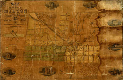
Map of the Town of Milton, County of Halton, Canada West
Description
- Creator
- Livingston, T. C., Cartographer
- Media Type
- Image
- Item Types
- Maps
- Measured drawings
- Description
- Coloured engraved map of the Town of Milton showing wards, lot lines and numbers, property owners, outlines of buildings and ward boundaries. Details include engravings (clockwise from top left): "ladies Seminary, John Sproat, Esq. Proprietor", "Residence of John Martin Esq.", "Halton Mills, Messrs. White & Martin Proprietors", "Grammar & Common School", "Iron Foundry, S. Morse Proprietor", "Court House", "Residence of Dr. Freeman", "Residence of Dr. Hume",
- Inscriptions
- "Map of the Town of Milton, County of Halton, Canada West compiled from original plans and actual surveys by T. C. Livingston P.L.S. Milton January 1st, 1858. Engraved By Maclear & Co. Toronto"
- Publisher
- Maclear & Co.
- Place of Publication
- Toronto, ON
- Date of Original
- 1 Jan 1858
- Subject(s)
- Language of Item
- English
- Geographic Coverage
-
-
Ontario, Canada
Latitude: 43.514198796858 Longitude: -79.8721504211426
-
- Copyright Statement
- Copyright © Milton Historical Society. All rights reserved.
- Contact
- Milton Historical SocietyEmail:info@miltonhistoricalsociety.ca
Website:
Agency street/mail address:16 James St.,
Milton, Ontario,
L9T 2P4.


