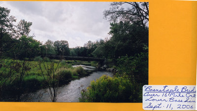
Barnstable Bridge, 2006
Description
- Media Type
- Image
- Item Type
- Photographs
- Description
- The Barnstable Bridge crosses the eastern arm of the Sixteen Mile Creek at Lower Base Line in Halton, between Fifth and Sixth Lines.
- Notes
- The bridge was named for the Barnstaple family who owned the farm on the hill just above it. Municipal records now show the name as "Barnstable", not "Barnstaple" - the name long-time residents still use.
A family member tells us that "When the family came to Canada, the name was spelled Barnstable. Most, if not all the first generation born in Canada were registered with birth names as Barnstable but most of their death registrations were Barnstaple."
"This farm belonged to my grandfather's brother and the flats now covered with weeds were once the site of family reunion picnics in the 1940s and 1950s." - Date Of Event
- September 11, 2006
- Subject(s)
- Personal Name(s)
- Barnstaple, Barnstable
- Local identifier
- TTRMW000199
- Collection
- Trafalgar Township Historical Society
- Language of Item
- English
- Geographic Coverage
-
-
Ontario, Canada
Latitude: 43.53341 Longitude: -79.78293
-
- Copyright Statement
- Copyright status unknown. Responsibility for determining the copyright status and any use rests exclusively with the user.
- Recommended Citation
- Barnstable Bridge, 2006
- Contact
-
Trafalgar Township Historical Society Sponsor: Jeff Knoll, Local & Regional Councillor for Oakville Ward 5 – Town of Oakville/Regional Municipality of Halton


