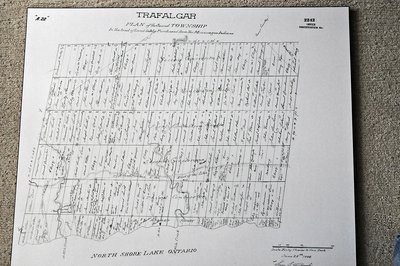
1806 Trafalgar Township Map
Description
- Media Type
- Image
- Text
- Item Type
- Maps
- Description
- In 1805, area native peoples gave up land on the north shore of Lake Ontario in what is now Oakville, Ontario. They kept the land surrounding the lower reaches of the Twelve and Sixteen Mile Creeks.
Samuel Street Wilmot surveyed the area and laid out two concessions north of Dundas Street and four concessions south of Dundas, with numbering going north and south from Dundas. Lot numbers go east to west. The names on the survey are names of those who received the original land grants resulting in a deed or patent.
According to the Wikipedia entry linked here, Trafalgar Township was one of the three townships surveyed by Samuel S. Wilmot.
You might also be interested in his biography, linked here from the Canadian Dictionary of Biography. - Notes
- This copy of the Wilmot survey map of Trafalgar Township was photographed from a wonderful display copy.
It looks like Mr. Wilmot signed his name, "Sam L. Wilmot", but it is actually "Sam S. Wilmot". - Inscriptions
- The heading on the map, "Trafalgar Plan of the Second Township In the Tract of Land Lately Purchased From the Mississauga Indians".
- Date of Publication
- 28 Jun 1806
- Date Of Event
- 1806
- Subject(s)
- Personal Name(s)
- Samuel Street Wilmot
- Local identifier
- TTMF00039
- Collection
- Trafalgar Township Historical Society
- Language of Item
- English
- Geographic Coverage
-
-
Ontario, Canada
Latitude: 43.4473682625124 Longitude: -79.6665048808289
-
- Copyright Statement
- Copyright status unknown. Responsibility for determining the copyright status and any use rests exclusively with the user.
- Recommended Citation
- 1806 Trafalgar Township Map
- Contact
-
Trafalgar Township Historical Society Sponsor: Jeff Knoll, Local & Regional Councillor for Oakville Ward 5 – Town of Oakville/Regional Municipality of Halton


