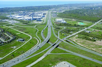
2005 Aerial Photograph of Oakville's Ford Plant and Intersection of the QEW, Ford Drive and Highway 403
Description
- Media Type
- Image
- Item Type
- Photographs
- Description
- We are looking southwest along the Queen Elizabeth Way to downtown Oakville and Lake Ontario, where Mississauga and Oakville meet at the old village area of Sheridan, just west of Winston Churchill Boulevard in Mississauga. Our collection also contains newspaper articles about the disappearance of Sheridan and resident memories of farm, community and church life.
To our left, is the subdivision in Oakville that lies on the west side of Winston Churchill Boulevard. The south service road curves around it and down and you can see the remnants of the old highway for a short distance.
The QEW is the main artery shown, with the Ford Drive exit branching off to the right, running parallel to the north service road.
The Highway 403 northbound goes under the above two roads and the southbout 403 lanes curve over them to join the QEW just past Ford Drive (known as Ninth Line further north).
The Ford plant is on the left or south side of the QEW with the smokestacks.
The Queen Elizabeth Way follows the old Upper Middle Road but was curved south at the Ford plant to bring it closer to the downtown of Oakville. It now follows the old Lower Middle Road, of which a short remnant remains between Ford Drive and the intersection of the railway tracks into the plant and Royal Windsor Drive.
The west end of Lake Ontario is shown in the far distance.
- Notes
- These high-resolution photographs are only a few of close to 200 that were taken by BP Imaging for the Town of Oakville in 2005. Town of Oakville Heritage Planning has shared these as well as another group of over 100 aerial photographs taken in 2002 with the Trafalgar Township Historical Society.
Several other records have been made with a few of the other photographs to this TTHS internet collection but not all have been put on the internet as there are too many. The other selected photographs from the collection are linked together under the "Oakville (including Bronte and the former Trafalgar Township) Aerial Photographs" Groups of Related Records.
All the aerial photographs may be viewed at the TTHS archives where they are digitally stored. - Date Of Event
- 2005
- Subject(s)
- Local identifier
- TTCVS000554
- Collection
- Trafalgar Township Historical Society
- Geographic Coverage
-
-
Ontario, Canada
Latitude: 43.4473682625124 Longitude: -79.6665048808289
-
- Copyright Statement
- Copyright status unknown. Responsibility for determining the copyright status and any use rests exclusively with the user.
- Recommended Citation
- 2005 Aerial Photograph of Oakville's Ford Plant and Intersection of the QEW, Ford Drive and Highway 403
- Contact
-
Trafalgar Township Historical Society Sponsor: Jeff Knoll, Local & Regional Councillor for Oakville Ward 5 – Town of Oakville/Regional Municipality of Halton