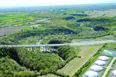
2005 Aerial Photographs, Near Halton Region Biosolids Management Centre
Description
- Media Type
- Image
- Item Type
- Photographs
- Description
- The domes are the Halton Region Biosolids Management Centre – apparently what planners officially call a “poop processor”.
The bridge is Highway 407 crossing over the Sixteen Mile Creek. The bridge is north of Burnhamthorpe Road and between Highway 25 and Neyagawa.
Click on "Pages" "Select" to see the 2nd photograph. It is taken from a bit further north and looks over the same area to the south. - Notes
- These high-resolution photographs are only a few of close to 200 that were taken by BP Imaging for the Town of Oakville in 2005. Town of Oakville Heritage Planning has shared these as well as another group of over 100 aerial photographs taken in 2002 with the Trafalgar Township Historical Society.
Several other records have been made with a few of the other photographs to this TTHS internet collection but not all have been put on the internet as there are too many. The other selected photographs from the collection are linked together under the "Oakville (including Bronte and the former Trafalgar Township) Aerial Photographs" Groups of Related Records.
All the aerial photographs may be viewed at the TTHS archives where they are digitally stored. - Date Of Event
- 2005
- Subject(s)
- Local identifier
- TTCVS000555
- Collection
- Trafalgar Township Historical Society
- Geographic Coverage
-
-
Ontario, Canada
Latitude: 43.43341 Longitude: -79.66631
-
- Copyright Statement
- Copyright status unknown. Responsibility for determining the copyright status and any use rests exclusively with the user.
- Recommended Citation
- 2005 Aerial Photographs, Near Halton Region Biosolids Management Centre
- Contact
-
Trafalgar Township Historical Society Sponsor: Jeff Knoll, Local & Regional Councillor for Oakville Ward 5 – Town of Oakville/Regional Municipality of Halton


