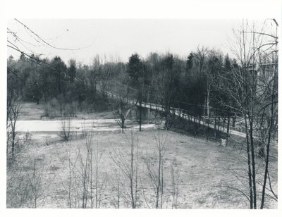
The Old Middle Road Bridge with the New Queen Elizabeth Way Highway Over Bronte Creek
Description
- Media Type
- Image
- Text
- Item Type
- Photographs
- Description
- If you look at the "Full" version of this photograph, you can see the Queen Elizabeth Way bridge spanning Twelve Mile Creek (Bronte Creek) near the upper right corner.
The bridge in the foreground is the former roadway known as the "Middle Road" across the Creek. For the most part, the QEW followed the former Middle Road through Oakville.
The road grades approaching the old bridge were steep, treacherous in bad weather.
The QEW was an Ontario Department of Highways construction project during the Depression. The Highway was dedicated in 1939.
This photo was likely taken in within a year or two of the Queen Elizabeth Way construction by George Atkins whose property, Woodlands, was just north of the new QEW at Bronte Road along the eastern Creek bluffs.
The upper iron trestles of the bridge aren't easily seen in this photograph but our collection has another photo taken by Mr. Atkins at about the same time that shows the bridge clearly.
An excellent Wikipedia article showing another clear photograph of the bridge with the new QEW bridge in the background is linked here for your further information. This article is an excellent essay on the construction of Ontario's Middle Road from Toronto to Hamilton, and it also explains why people referred to the road by various names until its official opening in August 1940.
- Notes
- This photograph taken by George Stuart Atkins have been shared with the Trafalgar Township Historical Society by the Bronte Historical Society. The Bronte Historical Society has a wealth of information on the Bronte area of Halton County, Ontario. A link to their website is provided for your further information.
- Subject(s)
- Personal Name(s)
- Atkins, George Stuart
- Local identifier
- TTGSA000613
- Collection
- Trafalgar Township Historical Society
- Language of Item
- English
- Geographic Coverage
-
-
Ontario, Canada
Latitude: 43.4108 Longitude: -79.74035
-
- Copyright Statement
- Copyright status unknown. Responsibility for determining the copyright status and any use rests exclusively with the user.
- Recommended Citation
- The Old Middle Road Bridge with the New Queen Elizabeth Way Highway Over Bronte Creek
- Contact
-
Trafalgar Township Historical Society Sponsor: Jeff Knoll, Local & Regional Councillor for Oakville Ward 5 – Town of Oakville/Regional Municipality of Halton


