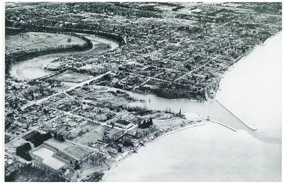
Pre1948 Oakville Town Aerial Photo
Description
- Media Type
- Image
- Item Type
- Photographs
- Description
- An aerial photograph of the town of Oakville, focused on the Sixteen Mile Creek opening into Lake Ontario. The photograph was taken prior to August 16, 1948 because on that date, the tall building visible on the southwest corner of Navy and Colborne Streets (Colborne is now Lakeshore Road), home to the Kendall Leather Company, burned on August 16, 1948. Apparently, the Oakville Fire Department had to use a special pumper, Pumper No. 8, to fight this fire. James R. Kendall was the business owner.
The Reservoir on the east side of Kerr Street is visible in the lower left corner, the park on the east side of the reservoir was called, "Reservoir Park".
North of the Colborne Street traffic bridge is the Radial bridge. In modern times, the Rebecca Street traffic bridge has taken the place of the old railway bridge. At the south-east end of the Radial bridge is Central School. You can see the schoolyard going south from the multi-story school building.
On the east side of the harbour mouth is the Custom House (at Erchless) which was in use as a Customs House until the 1930's when the harbour ceased to be used commercially (replaced by the railroad.)
North of the Erchless property, you can see the lawn bowling club green, then further north and closer to the Creek, you can see the 3 story Granary (it sits along Robinson Street going west from Navy Street just below Colborne Street) where grain had long been stored in preparation for shipping from the harbour.
You can barely see the lighthouse sitting out into Lake Ontario on the east breakwater/harbour entrance wall.
It looks like a trawler or stone-boat is docked on the west bank of the Sixteen across from the Oakville Club which was formed in 1907 on the east side.
On the west side, just south of the bridge, you can see buildings and docks - this is now Shipyard Park but was previously the location of Captain Andrew’s shipyard (which occupied both sides of the creek), where such crafts as the Canada - winner of the Canada's Cup in 1896, and Invader, winner in 1901, were built.
Please contact us if you have stories or information about other places, buildings or features connected with this photograph. We'd like to add to the information here. - Subject(s)
- Local identifier
- TTRMW000640
- Collection
- Trafalgar Township Historical Society
- Geographic Coverage
-
-
Ontario, Canada
Latitude: 43.4473682625124 Longitude: -79.6665048808289
-
- Copyright Statement
- Copyright status unknown. Responsibility for determining the copyright status and any use rests exclusively with the user.
- Recommended Citation
- Pre1948 Oakville Town Aerial Photo
- Contact
-
Trafalgar Township Historical Society Sponsor: Jeff Knoll, Local & Regional Councillor for Oakville Ward 5 – Town of Oakville/Regional Municipality of Halton


