Iron Trestle Section of The Road Bridge Over The Twelve Mile Creek
Description
- Media Type
- Image
- Item Type
- Photographs
- Description
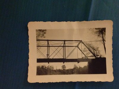
- Information from our donor was that this is a view of the old iron trestle train bridge crossing Bronte Creek (aka Twelve Mile Creek) just south of the Queen Elizabeth Way highway in the southwest corner of Oakville, Ontario. The photo was taken in October 1947 and was said to be showing it at time of demolition. Our record was previously titled, "Demolition of the Twelve Mile Creek Train Bridge in 1947". The new Queen Elizabeth Way high-level road bridge can be faintly seen in the background.
However, after receiving several comments disputing this as a train bridge, we consulted with knowledgeable people who took time to research and provide proof of their opinions that this is indeed not a rail bridge.
For one thing, the structure is far too light to support a train and its loads. Another point is that, although not clear in this picture, the grades to get a train down to the low level of this bridge would have been far too steep.
It is clear that this photo is of the old Middle Road, a section of its iron bridge trestle over the Twelve Mile Creek. See better views in the other photos linked to this record; those in the Wikipedia link, the "Bronte Bridge" photo of both bridges on the Queen Elizabeth Way section of www.thekingshighway.ca website, those of immediate neighbour George Atkins.
The QEW was built along the bed of the Middle Road to a great extent. Correspondent "the barefoothiker.ca" says, "The surviving (western) bridge abutment immediately south of the QEW at Bronte Creek is literally just a few dozen metres away from the newer (QEW) span."
Another correspondent sent the Google Map view of the high-level rail crossing over the river further south linked in this record. This train bridge has long sat on the original 6 supports. The supports are made of ironstone which is used to this day when solid stable supports are required.
- Notes
- The QEW was an Ontario Department of Highways construction project during the Depression. The highway was in use in 1939, formally opened in 1940. A link to the excellent Wikipedia page on "The Middle Road" between Toronto and Hamilton in Ontario is provided for your further information. It includes an excellent photograph of the road bridges. The Wikipedia photograph clearly shows the Middle Road bridge was low, close to the water which meant that the road grades approaching the old bridge were steep, treacherous in bad weather. The new, high level bridge shows to the north.
The road bridge could also be referred to as the Merton bridge, the Middle Road bridge, the Bronte bridge, the Twelve Mile Creek bridge. The road was called the Middle Road until the Queen Elizabeth Way superseded it.
- Date of Original
- 1947
- Subject(s)
- Local identifier
- TTJPB000707
- Collection
- Trafalgar Township Historical Society
- Geographic Coverage
-
-
Ontario, Canada
Latitude: 43.4108 Longitude: -79.74035
-
- Copyright Statement
- Copyright status unknown. Responsibility for determining the copyright status and any use rests exclusively with the user.
- Recommended Citation
- Iron Trestle Section of The Road Bridge Over The Twelve Mile Creek
- Contact
-
Trafalgar Township Historical Society Sponsor: Jeff Knoll, Local & Regional Councillor for Oakville Ward 5 – Town of Oakville/Regional Municipality of Halton