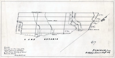
A map of the land purchased from the Mississaugas in 1806
Description
- Media Type
- Image
- Item Type
- Maps
- Description
- A map of the land purchased from the Mississaugas in 1806
- Inscriptions
- Remarks:
This map is a true copy of the original which is in possession of the Ontario Ministry of Natural Resources, Toronto.
James Madill, 1974
PURCHASE from the Mississauga Indians in the year 1806 - Date of Publication
- 1806
- Subject(s)
- Language of Item
- English
- Geographic Coverage
-
-
Ontario, Canada
Latitude: 43.4473682625124 Longitude: -79.6665048808289
-
- Copyright Statement
- Copyright status unknown. Responsibility for determining the copyright status and any use rests exclusively with the user.
- Contact
- Oakville Public LibraryEmail:oplreference@oakville.ca
Website:
Agency street/mail address:Oakville Public Library
Central Branch
120 Navy Street
Oakville, ON L6J 2Z4
Tel: (905) 815-2042
For information about photographs, news articles, or other information included in this database, please contact the Local Collections Librarian by email.