Tremaine's Map of the County of Halton 1858 - Nelson
Description
- Creator
- Geo. R. Tremaine
- Media Type
- Image
- Item Type
- Maps
- Description
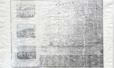
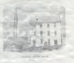
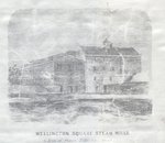
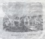
- This map lays out the land division and ownership of the Nelson region as of 1858. It is one of eight maps of the Halton townships. It also includes depictions of important local buildings including the Bronte Steam Mills, Wellington Square Steam Mills, and the Residence of John Triller Esq. Section 7 of 8.
- Date of Original
- 1858
- Date Of Event
- 1858
- Subject(s)
- Local identifier
- OPLOIH0003
- Geographic Coverage
-
-
Ontario, Canada
Latitude: 43.41681 Longitude: -79.86633
-
- Copyright Statement
- Public domain: Copyright has expired according to Canadian law. No restrictions on use.
- Contact
- Oakville Public LibraryEmail:oplreference@oakville.ca
Website:
Agency street/mail address:Oakville Public Library
Central Branch
120 Navy Street
Oakville, ON L6J 2Z4
Tel: (905) 815-2042
For information about photographs, news articles, or other information included in this database, please contact the Local Collections Librarian by email.