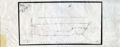
Sketch of Land Purchase from the Mississauga Indians 1805
Description
- Creator
- C.B. Wyatt
- Media Type
- Image
- Item Types
- Drawings
- Maps
- Description
- This map shows the land purchased from the Mississaugas in 1805. This land is located between the Etobicoke River and Burlington Bay. H3/420 Halton.
- Notes
- In 1787-88 the Toronto Purchase was made in absence of legal documents between Sir John Johnson and the Mississaugas, because of the former absence of legal documents the agreements was confirmed in 1805 with the Mississauga Indians at the River Credit reaffirming the old boundaries of 1787-88.
- Inscriptions
- Reverse:
BRIEF TITLE: Sketch of the Tract purchased from the Mississague Indians. C.B. Wyatt
SCALE: 1 inch to 2 miles
CROSS REFERENCES: AREA: 420 Feet.
REMARKS: In 1787-88 the Toronto Purchase was made in absence of legal documents between Sir John Johnson and the Mississaugas, because of the former absence of legal documents the agreements was confirmed in 1805 with the Mississauga Indians at the River Credit reaffirming the old boundaries of 1787-88. - Date of Original
- 1805
- Date Of Event
- 1805
- Subject(s)
- Local identifier
- OPLOIMI0001
- Language of Item
- English
- Geographic Coverage
-
-
Ontario, Canada
Latitude: 43.4473682625124 Longitude: -79.6665048808289 -
Ontario, Canada
Latitude: 43.5425757224692 Longitude: -79.610710144043
-
- Copyright Statement
- Public domain: Copyright has expired according to Canadian law. No restrictions on use.
- Contact
- Oakville Public LibraryEmail:oplreference@oakville.ca
Website:
Agency street/mail address:Oakville Public Library
Central Branch
120 Navy Street
Oakville, ON L6J 2Z4
Tel: (905) 815-2042
For information about photographs, news articles, or other information included in this database, please contact the Local Collections Librarian by email.


