Map of Oakville 1837
Description
- Media Type
- Image
- Item Type
- Maps
- Description
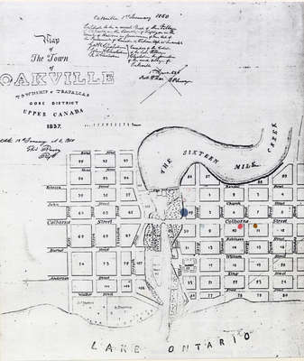
- This map shows the land division of the town of Oakville within the township of Trafalgar as of 1837. The map covers the land between Dundas and Kerr Street. It also depicts the Sixteen Mile Creek and the Reserve located just east of Kerr Street.
- Notes
- The Drawing has been prepared from information gathered from a copy of the first registered plan of Oakville, by Deputy Provincial Surveyor, Robert W. Kerr in 1836, under the direction of Col. William Chisholm, the founder of Oakville. The Plan was registered January 12th 1850.
James Madill, Oakville, 1973 - Date of Original
- 1837
- Date Of Event
- 1837
- Subject(s)
- Local identifier
- OPLOIMO0001
- Language of Item
- English
- Geographic Coverage
-
-
Ontario, Canada
Latitude: 43.4473682625124 Longitude: -79.6665048808289
-
- Copyright Statement
- Public domain: Copyright has expired according to Canadian law. No restrictions on use.
- Contact
- Oakville Public LibraryEmail:oplreference@oakville.ca
Website:
Agency street/mail address:Oakville Public Library
Central Branch
120 Navy Street
Oakville, ON L6J 2Z4
Tel: (905) 815-2042
For information about photographs, news articles, or other information included in this database, please contact the Local Collections Librarian by email.