Map of Bronte 1877
Description
- Creator
- J.H. Pope
- Media Type
- Image
- Item Type
- Maps
- Description
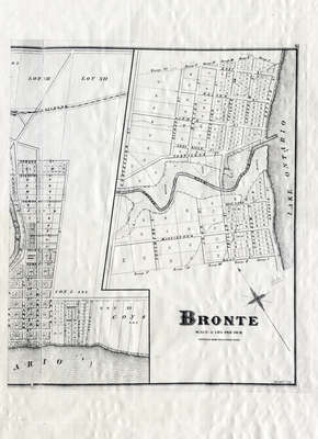
- This map depicts the land division of the Town of Bronte, which, at this time, stretched from West St. in the west. East St. in the East, Concession St. in the north and Lake Ontario in the South. It also includes the plan of Oakville east of Dunn St. AT/440 – Oakville.
- Subject(s)
- Local identifier
- OPLOIBRT0001
- Language of Item
- English
- Geographic Coverage
-
-
Ontario, Canada
Latitude: 43.40011 Longitude: -79.71632
-
- Copyright Statement
- Public domain: Copyright has expired according to Canadian law. No restrictions on use.
- Contact
- Oakville Public LibraryEmail:oplreference@oakville.ca
Website:
Agency street/mail address:Oakville Public Library
Central Branch
120 Navy Street
Oakville, ON L6J 2Z4
Tel: (905) 815-2042
For information about photographs, news articles, or other information included in this database, please contact the Local Collections Librarian by email.