Plan of Oakville 1876
Description
- Media Type
- Image
- Item Type
- Maps
- Description
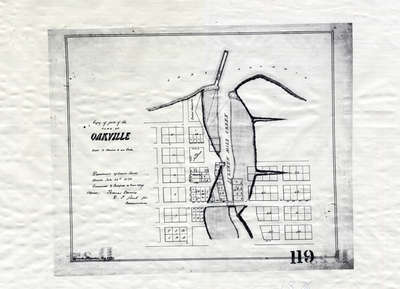
- This map shows the division of land in Oakville surrounding the Sixteen Mile Creek. It was verified by the Department of Crown Lands the same year it was created.
- Inscriptions
- Scale 4 Chains to an Inch.
Department of Crown Lands
Toronto July 29th 2876
Examined and Certified a true copy
(Signed) Thomas Devine
D.S. _____ for Commissioner - Date of Original
- 1876
- Date Of Event
- 1876
- Subject(s)
- Local identifier
- OPLOIOKV0001
- Language of Item
- English
- Geographic Coverage
-
-
Ontario, Canada
Latitude: 43.4473682625124 Longitude: -79.6665048808289
-
- Copyright Statement
- Public domain: Copyright has expired according to Canadian law. No restrictions on use.
- Contact
- Oakville Public LibraryEmail:oplreference@oakville.ca
Website:
Agency street/mail address:Oakville Public Library
Central Branch
120 Navy Street
Oakville, ON L6J 2Z4
Tel: (905) 815-2042
For information about photographs, news articles, or other information included in this database, please contact the Local Collections Librarian by email.