Map of Oakville 1877
Description
- Media Type
- Image
- Item Type
- Maps
- Description
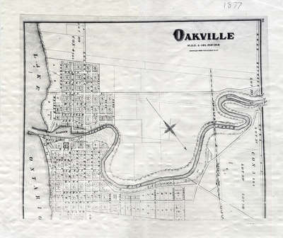
- This map shows the land division between Brock Street in west Oakville and Allan Street in east Oakville. Taken from the Illustrated Historical Atlas of Halton. AT/440 – Oakville – 1877.
- Notes
- This map was compiled using original registered surveys from J.H. Pope.
- Publisher
- Walker & Miles
- Place of Publication
- Toronto
- Date of Original
- 1877
- Date Of Event
- 1877
- Subject(s)
- Local identifier
- OPLOIHAH0002
- Language of Item
- English
- Geographic Coverage
-
-
Ontario, Canada
Latitude: 43.4473682625124 Longitude: -79.6665048808289
-
- Copyright Statement
- Public domain: Copyright has expired according to Canadian law. No restrictions on use.
- Contact
- Oakville Public LibraryEmail:oplreference@oakville.ca
Website:
Agency street/mail address:Oakville Public Library
Central Branch
120 Navy Street
Oakville, ON L6J 2Z4
Tel: (905) 815-2042
For information about photographs, news articles, or other information included in this database, please contact the Local Collections Librarian by email.