Plan of Oakville, Township of Trafalgar, Upper Canada, 1835
Description
- Creator
- Edward B. Palmer
- Media Type
- Image
- Item Type
- Maps
- Description
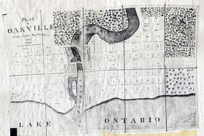
- A map from 1835 showing the town of Oakville from Brock Street to Allan Street, including the Sixteen Mile Creek. This map features the church, market square, wharf and an intended damn site north of the Colborne Street bridge.
- Date of Original
- 1835
- Date Of Event
- 1835
- Subject(s)
- Local identifier
- OPLOIOTT0001
- Language of Item
- English
- Geographic Coverage
-
-
Ontario, Canada
Latitude: 43.4451922192531 Longitude: -79.6706199645996
-
- Copyright Statement
- Public domain: Copyright has expired according to Canadian law. No restrictions on use.
- Contact
- Oakville Public LibraryEmail:oplreference@oakville.ca
Website:
Agency street/mail address:Oakville Public Library
Central Branch
120 Navy Street
Oakville, ON L6J 2Z4
Tel: (905) 815-2042
For information about photographs, news articles, or other information included in this database, please contact the Local Collections Librarian by email.