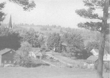
Hilltop view of Norval
Description
- Media Type
- Image
- Item Type
- Photographs
- Description
- Hilltop view of Norval before Highway # 7 went through the village. Description on back of photo: "When the highway # 7 first went through the village about 1920 or 1921, we lost some of our trees, but some of the big chestnuts and maples were saved. At one time you could walk in the shade down both sides of the street, walnuts and maples on the Presbyterian property, maples at McPhersons, chestnuts at Websters, the huge old Snow apples hanging over the picket fence at Watson's and two butternuts in front of the tennis courts between Hustler's store and Bert Hunter's house. Seen from Russell's hill, most of the village was hidden. The barn you see stabled the Anglican Rector's horse and cow but by 1925 the livestock was gone. A fair number of the villagers kept a few chickens and you would see the odd pig here and there. One elderly gentleman whose garden routine was always dictated by the phases of the moon, also butchered his yearly pig when the moon was "right" so the sausages would double in size when you fried them. Well, maybe, who knows."
- Notes
- This is one of series of photo/postcards designed and scripted by Mary Maxwell in c1990. Mary is a long time Norval resident.
- Date of Original
- c1920
- Date Of Event
- 1920
- Subject(s)
- Local identifier
- p10820f.jpg
- Geographic Coverage
-
-
Ontario, Canada
Latitude: 43.65011 Longitude: -79.84963
-
- Copyright Statement
- Copyright status unknown. Responsibility for determining the copyright status and any use rests exclusively with the user.
- Contact
- Esquesing Historical SocietyEmail:esquesinghs@gmail.com
Website:
Agency street/mail address:P.O. Box 51,
Georgetown, ON L7G 4T1


