Illinois News Index

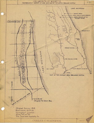
The Growth of Wilmette: Government survey of 1818 and Map of the Area's Drainage System

Description
Creator
Henderson, Charles Clinton, Cartographer
Media Type
Text
Image
Item Type
Maps
Notes
Map adapted from original survey in 1818 and a resurvey, 1837-1839
Date of Publication
Aug 1949
Subject(s)
Local identifier
Maps 1.2
Language of Item
English
Geographic Coverage
  • Illinois, United States
    Latitude: 42.07225 Longitude: -87.72284
Copyright Statement
Copyright status unknown. Responsibility for determining the copyright status and any use rests exclusively with the user.
Contact
Wilmette Public Library
Email:refdesk@wilmettelibrary.info
Website:
Agency street/mail address:
1242 Wilmette Avenue
Wilmette, IL
60091-2558
U.S.A. Phone: 847-256-6930
Full Text

Original Survey 1818

Resurveyed 1837-39

Government Surveys Atlas #65, p.39

Title Trust and Guaranty Co.

Map shows U.S. Road from Chicago to Green Bay, Indian Boundary Line 1876, Lake Michigan, Road to Gross Point

Map of the Chicago Area Drainiage system shows Skokie Creek; East Fork of the North Branch; North Branch of the Chicago River; Grosse Point; Canal 1906; Chicago River; Des Plaines River, Salt Creek ; South Branch of the Chicago River

Powered by / Alimenté par VITA Toolkit
Privacy Policy