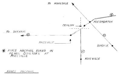
Map of Agnes Macphail locales in Grey County Part 2
Description
- Créateur
- Archie Huston, Illustrator
- Médias
- Image
- Type d'élément
- Maps
- Description
- Hand drawn map that contextualizes significant locations in Agnes Macphail's life and indicates the cemetery where she is buried.
- Date de l'original
- c.1995
- Date d'événement
- 1890-1954
- Dimensions
-
Largeur: 28 cm
Hauteur: 22 cm
- Sujet(s)
- Identifiant local
- 996.023.013b
- Langage de l'élément
- English
- Couverture géographique
-
-
Ontario, Canada
Latitude: 44.2501 Longitude: -80.5664
-
- Déclaration de droit d'auteur
- Protected by copyright: Uses other than research or private study require the permission of the rightsholder(s). Responsibility for obtaining permissions and for any use rests exclusively with the user.
- Détenteur du droit d'auteur
- Archie Huston
- Conditions d'utilisation
- Reproduction of digital objects is restricted to fair use for personal study or research, any other use must be done with permission of copyright holder.
- Notes de reproduction
- Copy of this map is held at Grey Roots Museum & Archives
- Contacter
- South Grey Museum


