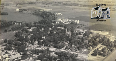
Aerial View of St. Marys
Description
- Médias
- Image
- Type d'élément
- Photographs
- Description
- This photograph shows an aerial view of some of the north ward of St. Marys. On the left, you can see the Sarnia Bridge, the Thames River, and the Flats (Milt Dunnell Field). Two church spires are also visible: the Presbyterian Church (left) and Holy Name of Mary Catholic Church (right).
- Notes
- Condition: good.
- Dimensions
-
Largeur: 25.3 cm
Hauteur: 14 cm
- Dimensions d'image
-
Largeur d'image: 25.8cm
Hauteur d'image: 13.7cm
- Sujet(s)
- Identifiant local
- macke115
- Collection
- Macke Collection
- Langage de l'élément
- English
- Couverture géographique
-
-
Ontario, Canada
Latitude: 43.2628420286143 Longitude: -81.1432538519287
-
- Donneur
- Marlene Macke
- Déclaration de droit d'auteur
- Copyright status unknown. Responsibility for determining the copyright status and any use rests exclusively with the user.
- Citation recommandée
- Macke Collection. "Aerial View of St. Marys" St. Marys Museum, macke115.
- Emplacement d'original
- Location of original is unknown. Copy is in R. Lorne Eedy Archives.
- Conditions d'utilisation
- Reproduction of digital objects is restricted to fair use for personal study or research; any other use must be done with permission of copyright holder.
- Notes de reproduction
- This image is a watermarked low resolution reproduction.
High resolution images are available at the St. Marys Museum for a fee. - Contacter
- St. Marys MuseumCourriel:museum@town.stmarys.on.ca
Adresse Internet:
Adresse postale d'agence177 Church Street South,
P.O. Box 998,
St. Marys, Ontario.
N4X 1B6


