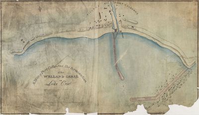
A Map of Port Colborne: the termination of the Welland Canal on Lake Erie, 1837
Description
- Médias
- Image
- Type d'élément
- Maps
- Description
- An map of Gravelly Bay, and Port Colborne harbour drawn by canal engineer, H. H. Killaly, illustrating proposed plans for new pier extensions and a new lighthouse.
- Notes
- Original in collection of LAC H1/440/Port Colborne/[1837]
- Date
- 1837
- Langage de l'élément
- English
- Déclaration de droit d'auteur
- Copyright status unknown. Responsibility for determining the copyright status and any use rests exclusively with the user.
- Contacter
- Port Colborne Historical and Marine MuseumCourriel:archives@portcolborne.ca
Adresse Internet:
Adresse postale d'agence280 King St. Box 572
Port Colborne, ON L3K 5X8


