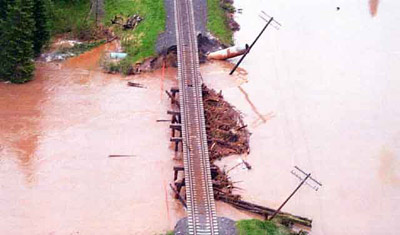
Aerial View of Washout
Description
- Question mystère
- If you are able to provide any identifying information for this image, please post a comment or contact reference@tbpl.ca[Pour répondre, cliquez SVP sur l'onglet Commentaires]
- Créateur
- John Sirman, Photographer
- Médias
- Image
- Type d'élément
- Photographs
- Description
- In this photo we see the damage to C.N.R. tracks, hydro lines and culverts that resulted after the heavy rainfall in June 2002. This aerial photo was taken two miles from Flanders Station near Rainy River, Ontario.
- Date de l'original
- June 11, 2002
- Sujet(s)
- Collection
- Rainy River Public Library
- Langage de l'élément
- English
- Couverture géographique
-
-
Ontario, Canada
Latitude: 48.71664 Longitude: -94.56711
-
- Déclaration de droit d'auteur
- Copyright status for this image is unknown. Should you have any identifying information for this image, please contact the Rainy River Public Library. Responsibility for determining the copyright status and any use rests exclusively with the user.
- Contacter
- Rainy River Public LibraryCourriel:libraryrr@gmail.com
Adresse Internet:
Adresse postale d'agence334 4th St.
PO Box 308
Rainy River, ON
P0W 1L0

