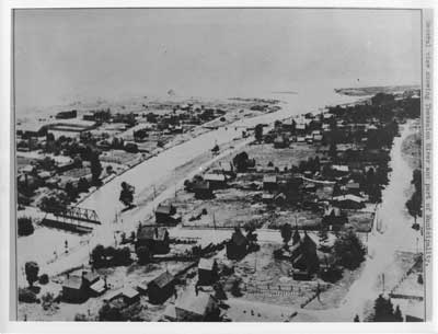
Aerial view of Thessalon River, circa 1935
Description
- Question mystère
- What year would this photo have been taken?[Pour répondre, cliquez SVP sur l'onglet Commentaires]
- Médias
- Image
- Type d'élément
- Aerial photographs
- Description
- This is a reproduction of a black and white aerial photograph that shows the east side of Thessalon, the Thessalon river, two bridges crossing it, and some of the west side of the town.
- Notes
- This unmarked and undated photo was located in miscellaneous municipal files and permission was granted to scan this photo to add to our local collection.
- Inscriptions
- "General view showing Thessalon River and part of Municipality."
- Date de l'original
- Circa 1935
- Dimensions
-
Largeur: 10 in
Hauteur: 8 in
- Sujet(s)
- Identifiant local
- Thessalon Municipal Office
- Langage de l'élément
- English
- Couverture géographique
-
-
Ontario, Canada
Latitude: 46.25006 Longitude: -83.5666
-
- Déclaration de droit d'auteur
- Protected by copyright: Uses other than research or private study require the permission of the rightsholder(s). Responsibility for obtaining permissions and for any use rests exclusively with the user.
- Contacter
- Heritage Park MuseumCourriel:thessalonlib@hotmail.com
Adresse postale d'agenceP.O. Box 425
Thessalon, ON
P0R 1L0

