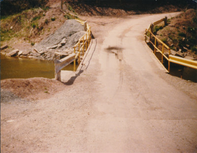
Glenorchy Bridge Construction, mid1980's
Description
- Media Type
- Image
- Item Type
- Photographs
- Description
- Construction of the level bridge crossing of the Sixteen Mile Creek at Glenorchy sometime in the 1980's. This was the second bridge to be built here. It was built on the same abutments as the first, but in 2001, the crossing became a bicycle/pedestrian crossing only as the area is prone to flooding and the north bank road up to Lower Base Line is so very steep.
The bridge at Glenorchy crossed an arm of the Sixteen Mile Creek at Fourth Line just below the Lower Baseline Rd., Halton County. The site is particularly remembered for the old school which had been built nearby in the river floodplain - people remember the river ice pushing up against the school, and for the collapse of the seventy year old bridge in 1963 when a truck with a heavy load of potatoes tried to drive over it. Another record in our collection has a record with photographs of the truck accident and explanation of how such a large transport came to be on such a hairpin road. - Subject(s)
- Local identifier
- TTDAS000646
- Collection
- Trafalgar Township Historical Society
- Geographic Coverage
-
-
Ontario, Canada
Latitude: 43.4861345348332 Longitude: -79.7845046482849
-
- Copyright Statement
- Copyright status unknown. Responsibility for determining the copyright status and any use rests exclusively with the user.
- Recommended Citation
- Second Glenorchy Bridge Construction
- Contact
-
Trafalgar Township Historical Society Sponsor: Jeff Knoll, Local & Regional Councillor for Oakville Ward 5 – Town of Oakville/Regional Municipality of Halton


