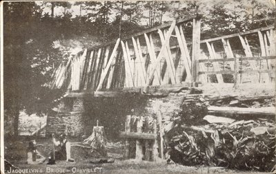
Jacquelyn's Bridge, 1916
Description
- Mystery Question
- Why was this bridge on the Fourth Line, Halton County over the Sixteen Mile Creek named "Jacquelyn's Bridge"?[Please answer by clicking on the Comments tab]
- Media Type
- Image
- Item Type
- Postcards
- Description
- November 2011; a comment has been received that this bridge is possibly the original one that carried Fourth Line north over the Sixteen Mile Creek at Lower Base Line. "Jacquelyn's Bridge" would have been about 100 feet further along of the present day north side bridge abutment shown in the 2nd recent photograph included in this record. See the modern day photograph by clicking on the drop-down menu of "Pages" "Select" above. Today, Fourth Line is closed in this area just north of Highway 407. After crossing the Creek, the old road rises steeply up the side of the cliff above the river.
The commenter adds, "There's a remnant of abutment about half way down the closed road on the north side that strongly reminds me of the one seen on the left side of this photo, and it is faced immediately by the face of the cut, as this one is here."
A link to the Google Maps satellite imagery of the location is also included in this record for your further information. The url is: http://maps.google.com/?ll=43.483413,-79.773341&spn=0.001621,0.002693&t=h&z=19&vpsrc=6
2017 Update: Information has been received about the above bridge from the Wilson family, family of Ernest and Minnie Henderson. The above information is correct. This is not - as has been often suggested - the Henderson Park bridge which is on Lower Base Line just east of Regional Road 25. Henderson Bridge was originally built as a 70 foot single lane steel truss bridge with wooden plank decking on stone masonry that was in place pre1900. Repairs in 1969 and 1981 removed much of the original bridge. See our other internet records on the Henderson family and Henderson Park for more information on the Henderson Bridge.
The local name of "Jacquelyn's Bridge" is not known to TTHS members; similar local names of bridges crossing the Sixteen are the "Barnstaple" bridge, as locals referred to the bridge just past the Barnstaple family farm, and the "Henderson" bridge, similarly named.
Notice the two men reclining on the southwest bank, posed to add interest to the photograph and to highlight the scenery. Postcards such as this one were commonly commissioned by local post offices for the use of visitors to the area.
One comment to this postcard record says that their copy of the same postcard was mailed in 1906. - Notes
- The technology embedded in today's digital camera photographs such as GPS location, compass orientation so we know which way the photographer was facing, date, even time of day will do more to help historians with these questions in the future.
- Inscriptions
- Front of postcard: "Jacquelyn's Bridge, Oakville".
Verso: PRIVATE POSTCARD ; 10/18/16 ; THIS SPACE MAY BE USED FOR MESSAGES ; One of the old time bridges outside Oakville Town. These are fast disappearing to make room for new ones suited to automobile traffic." - Date of Publication
- 1916
- Subject(s)
- Local identifier
- TTOIRMW0057
- Collection
- Trafalgar Township Historical Society
- Language of Item
- English
- Geographic Coverage
-
-
Ontario, Canada
Latitude: 43.662342340316 Longitude: -80.3227431054688
-
- Donor
- Ross Wark
- Copyright Statement
- Copyright status unknown. Responsibility for determining the copyright status and any use rests exclusively with the user.
- Recommended Citation
- Jacquelyn's Bridge, 1916
- Contact
-
Trafalgar Township Historical Society Sponsor: Jeff Knoll, Local & Regional Councillor for Oakville Ward 5 – Town of Oakville/Regional Municipality of Halton


