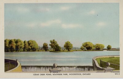
Cedar Creek Pond, Southside Park
Description
- Mystery Question
- Can you tell us where exactly in the park that this illustration is depicting?[Please answer by clicking on the Comments tab]
- Media Type
- Image
- Text
- Item Type
- Postcards
- Description
- This is an illustration of the creek that runs through Southside Park
- Inscriptions
- Cedar Creek Pond, Southside Park, Woodstock, Ontario
- Subject(s)
- Local identifier
- PC 96
- Collection
- Oxford County Archives Postcard Collection
- Language of Item
- English
- Geographic Coverage
-
-
Ontario, Canada
Latitude: 43.13339 Longitude: -80.83301 -
Cedar Creek Pond:
Ontario, Canada
Latitude: 43.1220518071973 Longitude: -80.7521890899658
-
- Copyright Statement
- Copyright status unknown. Responsibility for determining the copyright status and any use rests exclusively with the user.
- Recommended Citation
- Cedar Creek Pond Southside Park, Woodstock, Ontario. Oxford County Archives. [COA PC96]
- Reproduction Notes
- Please contact the Oxford County Archives for a higher resolution copy.
- Contact
- Oxford County ArchivesEmail:archives@oxfordcounty.ca
Agency street/mail address:82 Light St. Bo 1614
Woodstock, ON N4S 6H1


