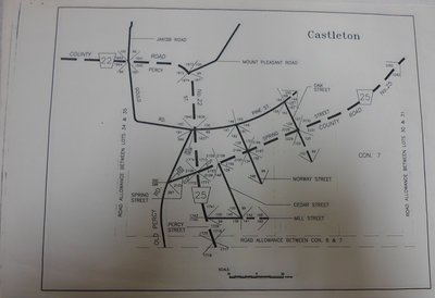
Photocopied Map of Castleton ca.2000
Description
- Media Type
- Image
- Description
- Mapmaker unknown.
- Notes
- Indicates road allowance and location numbers.
- Date of Original
- ca. 2000
- Subject(s)
- Local identifier
- 12mp
- Language of Item
- English
- Geographic Coverage
-
-
Ontario, Canada
Latitude: 44.0049356263776 Longitude: -77.8879498413086
-
- Copyright Statement
- Public domain: Copyright has expired according to Canadian law. No restrictions on use.
- Copyright Holder
- Copyright, public domain: Cramahe Township Public Library owns the rights to the archival copy of the digital image.
- Contact
- Cramahe Township Public LibraryEmail:cramlib@cramahetownship.ca
Website:
Agency street/mail address:6 King Street West
PO Box 190
Colborne, ON K0K 1S0


