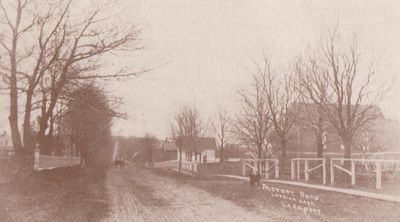
Factory Road, looking east, Lakeport
Description
- Herington & Son, Photographer
- Media Type
- Image
- Item Type
- Postcards
- Description
- This image was scanned from the publication - How Firm a Foundation: A History of the Township of Cramahe and the Village of Colborne in Cramahe's Digital Archives (3bk), p.40. The caption reads: "Lakeport Road, formerly known as Factory Road, looking east. The cemetery is on the left, St. Paul's Presbyterian Church on the right."
Argyris, Eileen. How Firm a Foundation: A History of the Township of Cramahe and the Village of Colborne. Erin, Ontario: Boston Mills Press, 2000. - Notes
- Cramahe Archives does not hold the original item in its archives, but has a digital image.
- Inscriptions
- On front: Factory Road, looking east, Lakeport
- Subject(s)
- Local identifier
- 129pd
- Language of Item
- English
- Geographic Coverage
-
-
Ontario, Canada
Latitude: 44.00012 Longitude: -77.8828
-
- Copyright Statement
- Copyright status unknown. Responsibility for determining the copyright status and any use rests exclusively with the user.
- Copyright Holder
- Copyright, public domain: Cramahe Township Public Library owns the rights to the archival copy of the digital image.
- Contact
- Cramahe Township Public LibraryEmail:cramlib@cramahetownship.ca
Website:
Agency street/mail address:6 King Street West
PO Box 190
Colborne, ON K0K 1S0


