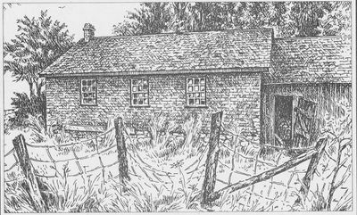
Sketch of the former Russ' School, School Section 20, Cramahe Township
Description
- Media Type
- Image
- Text
- Item Type
- Sketches
- Description
- Cobourg Daily Star, Saturday, September 21, 2001
Russ’ School, S.S. No. 20
Sketch and text by Barry King
"Located in the seventh concession of the former Haldimand Township, the first Russ’ School was built about 1845 when the school district was first organized. It was a frame or log structure built close to Dunbar Road at Russ Creek Road, and had an enrollment numbering 48 pupils. The desks were the double-seated variety common in pioneer days.
After this was destroyed by fire, a new brick structure was built a little to the north and adjacent to the cemetery lands in 1878. Robert Davidson from nearby Castleton was the builder.
Inside, the furnishings included double-seated desks, a box stove placed in the centre and a small stage for the teacher’s platform. Two small cloakrooms flanked the single entrance and, just overhead, at least in the early years, was the belfry.
Up until the 1930s water was often fetched from a nearby farm. Lacking electricity, the Christmas concerts were illuminated by lanterns brought by the proud parents who arrived in sleighs and cutters.
Abutting the south end of the structure was a large wood shed which afforded protection to the central entrance. A large beam that stretched the length of the shed provided a challenging climb for the most daring students.
Kept clean and tidy by a neighbouring family who also kindled the stove before classes commenced each morning, the school was the centre of the pioneer settlement of Russ Creek.
But, by 1947, only four pupils remained and the school closed for good. Left vacant with all its school treasures still intact, the building was the target of vandalism and finally burned to the ground in 1962. A final tribute was a reunion of old classmates and teachers which was held near the former site in 1985."
Cramahe Archives does not hold the original item in its archives, but has a digital image.
- Subject(s)
- Local identifier
- 12at
- Language of Item
- English
- Geographic Coverage
-
-
Ontario, Canada
Latitude: 44.00012 Longitude: -77.8828
-
- Copyright Statement
- Public domain: Copyright has expired according to Canadian law. No restrictions on use.
- Copyright Holder
- Copyright, public domain: Cramahe Township Public Library owns the rights to the archival copy of the digital image.
- Contact
- Cramahe Township Public LibraryEmail:cramlib@cramahetownship.ca
Website:
Agency street/mail address:6 King Street West
PO Box 190
Colborne, ON K0K 1S0


