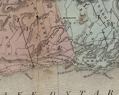
Cramahe Township map detail, Upper Canada, Tanner's Universal Atlas, 1836
Description
- Media Type
- Image
- Text
- Item Type
- Maps
- Description
- Catalogued by Toronto Public Library Digital Archive and downloaded from their site. See external link to the right of this record to access the original source of this map.
Upper Canada
Tanner, Henry Schenck, 1786-1858
Map, 1836, English
Notes From Tanner's Universal Atlas. Hand-coloured. Encapsulated with original cover: Seat of War in U. Canada
Publisher Philadelphia: H.S. Tanner
Rights and Licenses
Public Domain Medium
1 map : printed, colour
Extent38 cm. x 32 cm.
Branch Toronto Reference Library
Location Baldwin Collection
Call Number / Accession Number 912.713 T12 SMALL
- Notes
- A detail of the original map was taken to illustrate the location identified as Colborne.
- Date of Original
- 1836
- Subject(s)
- Language of Item
- English
- Geographic Coverage
-
-
Ontario, Canada
Latitude: 44.0049356263776 Longitude: -77.8879498413086
-
- Copyright Statement
- Public domain: Copyright has expired according to Canadian law. No restrictions on use.
- Copyright Holder
- Copyright, public domain: Cramahe Township Public Library owns the rights to the archival copy of the digital image.
- Contact
- Cramahe Township Public LibraryEmail:cramlib@cramahetownship.ca
Website:
Agency street/mail address:6 King Street West
PO Box 190
Colborne, ON K0K 1S0


