Ordinance
Description
- Creator
- Commissioner Crown Lands
- Media Type
- Text
- Image
- Item Types
- Documents
- Maps
- Description
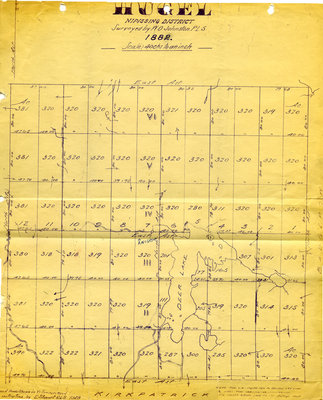
- Projected Plan of the Township of Hugel
- Notes
- Original map
- Date of Publication
- 15 May 1982
- Subject(s)
- Personal Name(s)
- Johnston, W.O.
- Corporate Name(s)
- Department of crown Lands, Toronto
- Collection
- Private collection
- Language of Item
- English
- Geographic Coverage
-
-
Ontario, Canada
Latitude: 46.4967813157701 Longitude: -80.2919086987305
-
- Creative Commons licence
 [more details]
- Copyright Statement
- Public domain: Copyright has expired according to Canadian law. No restrictions on use.
- Terms of Use
- Le matériel disponible ici peut être utilisé à des fins personnelles ou éducatives.L'utilisation de ce matériel devrait toujours inclure le crédit"Musée Sturgeon Rivver House".Pour toutes autres fins, notamment pour des fins commerciales, on ne peut,sans l'autorisation expresse du Musée Sturgeon River House et,s'il y a lieu, des autres titulaires des droits d'auteur, modifier, copier,reproduire, republier, afficher, transmettre ou distribuer le matériel, de quelque manière que ce soit. / The material provided here is for personal or educational purposes. Use of this material should include the credit to the “Museum Sturgeon RiverHouse”. Express permission from the Sturgeon River House Museum or other indicated copyright owners is required if you wish to modify, copy, reproduce, republish, post, transmit or distribute the material in any way for any other purposes, especially commercial.
- Contact
- Musée Sturgeon River House MuseumEmail:pn_dp@wnpl.ca
Website:
Agency street/mail address:250 Chemin Fort Road
Sturgeon Falls, ON P2B 2N7
Tel: 705-753-4716
Fax: 705-753-5476

