Sarnia Bridge
Description
- Media Type
- Image
- Item Type
- Photographs
- Description
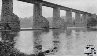
- This image is one in a series of postcards from the Reg Near collection. It is a photocopy of a photograph on the Sarnia Bridge, looking northeast across the Thames River. The Sarnia Bridge served the Grand Trunk Railway from 1859 to 1989, and in 1996 a committee was formed to redevelop the railway line through St. Marys into a walking trail. Since its inception, the Sarnia Bridge has been a landmark and image for tourists, photographers, and artists.
- Notes
- Condition: Fair - Slight bend in middle, fading throughout image.
- Inscriptions
- None
- Dimensions
-
Width: 13.9 cm
Height: 8.2 cm
- Image Dimensions
-
Image Width: 13.4cm
Image Height: 8.2cm
- Subject(s)
- Personal Name(s)
- Near, Reg.
- Local identifier
- RN7_138
- Collection
- Reg Near Postcards
- Geographic Coverage
-
-
Ontario, Canada
Latitude: 43.2629982869109 Longitude: -81.1486450920486
-
- Donor
- Reg Near
- Copyright Statement
- Copyright status unknown. Responsibility for determining the copyright status and any use rests exclusively with the user.
- Recommended Citation
- "Sarnia Bridge." St. Marys Museum, RN7_138.
- Location of Original
- R. Lorne Eedy Archives
- Terms of Use
- Reproduction of digital objects is restricted to fair use for personal research or study; any other use must be done with permission of copyright holder. As per request of donors on behalf of Reg Near, the original collection is to remain in the St. Marys Museum building and kept in the archival vault at all times. Retrieval from the vault is allowed for viewing under supervision of St. Marys Museum staff only.
- Reproduction Notes
- This image is a watermarked low resolution reproduction. High resolution images are available at the St. Marys Museum for a fee.
- Contact
- St. Marys MuseumEmail:museum@town.stmarys.on.ca
Website:
Agency street/mail address:177 Church Street South,
P.O. Box 998,
St. Marys, Ontario.
N4X 1B6


