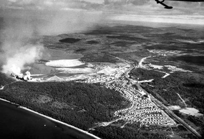
CPR Through Marathon
Description
- Creator
- Glenn Douglas
- Media Type
- Image
- Item Type
- Photographs
- Description
- The CPR tracks often defined the boundaries of many communities in Northwestern Ontario. In Marathon, the rail line formed the eastern most boundary from 1944 until about 1954, when new subdivisions started sprouting up 'across the tracks'.
- Date of Original
- 1952
- Subject(s)
- Local identifier
- M&DHS: 3
- Geographic Coverage
-
-
Ontario, Canada
Latitude: 48.7501 Longitude: -86.43322
-
- Copyright Statement
- Copyright status unknown. Responsibility for determining the copyright status and any use rests exclusively with the user.
- Contact
- Marathon District Museum & Historical SocietyEmail:marathonmuseum@gmail.com
Website:
Agency street/mail address:25 Stevens Avenue
Marathon, Ontario
P0T 2E0

