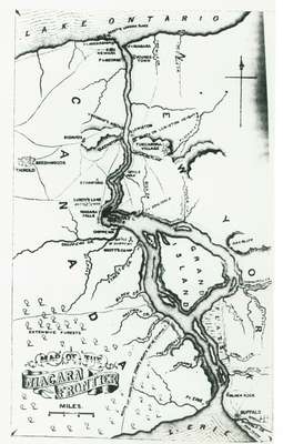
Map of the Niagara Frontier showing 1812-1814 Battle Sites
Description
- Sponsors

 This item is a part of the 1812 History digitization project. This project was made possible with the support of the Department of Canadian Heritage through the Canadian Culture Online Strategy.
- Media Type
- Image
- Item Type
- Maps
- Description
- A map of the Niagara Frontier which shows 1812-1814 battle sites. Possibly from "Lossing's Field Book of the War of 1812" dated 1869.
- Date Of Event
- 1812-1814
- Subject(s)
- Local identifier
- 989.5.425
- Language of Item
- English
- Geographic Coverage
-
-
Ontario, Canada
Latitude: 43.262222 Longitude: -79.073055
-
- Copyright Statement
- Protected by copyright: Uses other than research or private study require the permission of the rightsholder(s). Responsibility for obtaining permissions and for any use rests exclusively with the user.
- Recommended Citation
- Image courtesy of the Niagara Historical Society & Museum
- Terms of Use
- Please contact the Niagara Historical Society & Museum for any reproductions of this image.
- Contact
- Niagara Historical Society MuseumEmail:contact@niagarahistorical.museum
Website:
Agency street/mail address:43 Castlereagh Street
P.O. Box 208
Niagara-on-the-Lake, ON
L0S 1J0


