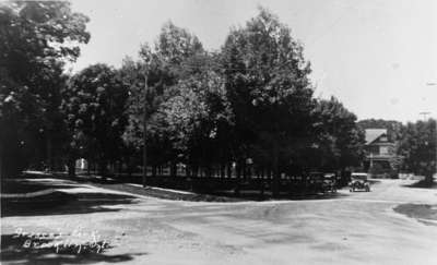
Grass Park
Description
- Creator
- Unknown, Photographer
- Media Type
- Image
- Item Type
- Postcards
- Description
- A black and white photograph of Grass Park. A house can be seen towards the right of the photograph in the background.
- Notes
- Grass Park is located at 41 Baldwin Street. It is a triangle shaped piece of land bounded by Roebuck Street, Baldwin Street and Mill Street (Cassels Road). This view is looking west from the intersection of Mill Street (Cassels Road) on the left, and Roebuck Street on the right. The park was owned by the Grass family until it was purchased by the village of Brooklin in 1951.
- Inscriptions
- Bottom right: Community Park, Brooklin, Ont.
- Date of Original
- c.1936
- Dimensions
-
Width: 6 cm
Height: 6 cm
- Image Dimensions
-
Image Width: 6cm
Image Height: 6cm
- Subject(s)
- Local identifier
- 25-000-075
- Language of Item
- English
- Geographic Coverage
-
-
Ontario, Canada
Latitude: 43.883333 Longitude: -78.933333
-
- Copyright Statement
- Public domain: Copyright has expired according to Canadian copyright law. No restrictions on use.
- Reproduction Notes
- Scanned from a copy negative.
- Contact
- Whitby Public LibraryEmail:archives@whitbylibrary.ca
Website:
Agency street/mail address:405 Dundas Street West, Whitby, Ontario L1N 6A1
For inquires about any newspaper content please contact askreference@whitbylibrary.ca


