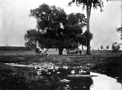
Jeffrey Flats/Lynde Creek
Description
- Creator
- W.E. O'Brien, Photographer
- Media Type
- Image
- Object
- Item Type
- Negatives
- Description
- Black and white negative depicting an image of the Jeffrey Flats. Lynde Creek is in the foreground and there are fields in the background. There are various people in the background too. It is possible that Kingston Road is in the background at left and the Jeffrey homestead is behind the tree.
- Notes
- Jeffrey Flats was the land south of Highway 2 (Kingston Road) through which runs Lynde Creek. The land was settled by William Jeffrey in 1834. The picture is a detail in the lower centre of a photo of the business and professional men of Whitby in 1895.
- Date of Original
- 1894
- Date Of Event
- 1894
- Subject(s)
- Local identifier
- 28-000-054
- Geographic Coverage
-
-
Ontario, Canada
Latitude: 43.8581730016329 Longitude: -78.9620018005371
-
- Copyright Statement
- Public domain: Copyright has expired according to Canadian copyright law. No restrictions on use.
- Recommended Citation
- Whitby Archives
- Reproduction Notes
- Scanned from copy negative
- Contact
- Whitby Public LibraryEmail:archives@whitbylibrary.ca
Website:
Agency street/mail address:405 Dundas Street West, Whitby, Ontario L1N 6A1
For inquires about any newspaper content please contact askreference@whitbylibrary.ca

