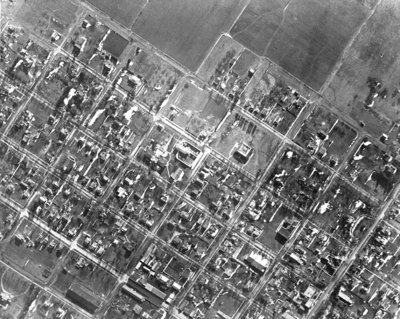
Whitby Aerial View, 1931
Description
- Creator
- G. Norman Irwin, Photographer
- Media Type
- Image
- Item Types
- Photographs
- Negatives
- Description
- Black and white negative of an aerial photograph of the south-west portion of Whitby. The street at the bottom left corner is Henry street and at the top right corner is Green Street and the Joseph King Estate. All Saints' Anglican Church is at the top left corner. The Theodore King Estate is at the bottom right.
- Date of Original
- March 1931
- Dimensions
-
Width: 7 cm
Height: 7.5 cm
- Subject(s)
- Local identifier
- 22-000-028
- Collection
- Whitby Online Historic Photographs Collection
- Geographic Coverage
-
-
Ontario, Canada
Latitude: 43.8797064242827 Longitude: -78.9419174194336
-
- Creative Commons licence
 [more details]
- Copyright Statement
- Public domain: Copyright has expired according to Canadian copyright law. No restrictions on use.
- Recommended Citation
- South-west Whitby Aerial View, 1931, G. Norman Irwin, Whitby Archives, 22-000-028.
- Reproduction Notes
- Scanned from copy negative.
- Contact
- Whitby Public LibraryEmail:archives@whitbylibrary.ca
Website:
Agency street/mail address:405 Dundas Street West, Whitby, Ontario L1N 6A1
For inquires about any newspaper content please contact askreference@whitbylibrary.ca

