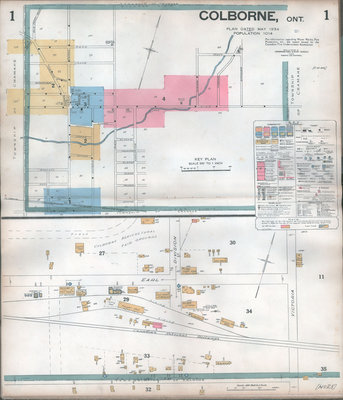
Insurance Plan (Goad Map) of the Town of Colborne, 1934 by Underwriters' Survey Bureau
Description
- Media Type
- Image
- Item Type
- Maps
- Description
- Map 1 - Overview of Colborne, key of symbols and detail of Division and Earl Streets
Map 2 - Percy, Toronto, Church, and King. Detail of North, Creek and Arthur
Map 3 - Church, King, North, Percy, Division, Maybee, and Victoria
Map 4 - King, Durham, and Furnace; King, Elgin, Simmons, and Church
Maps 1, 2 & 4: Scale 100 feet = 1 inch
Map 3: Scale 50 feet = 1 inch - Notes
- Highly detailed street level map with building / owner identified information. Use the drop down box at the top left of the screen to access the desired page. Click on the image to use the zoomify feature and see the details of the map. Keep clicking on the map to increase the level of detail and drag to move.
- Inscriptions
- Handwritten label, inside cover: "... Bought at Cliff Denny's Auction Barn, Colborne, Ont."
- Date of Original
- May 1934
- Subject(s)
- Corporate Name(s)
- Underwriters' Survey Bureau
- Local identifier
- 1mp
- Language of Item
- English
- Geographic Coverage
-
-
Ontario, Canada
Latitude: 44.0049356263776 Longitude: -77.8879498413086
-
- Copyright Statement
- Public domain: Copyright has expired according to Canadian law. No restrictions on use.
- Copyright Holder
- Copyright, public domain: Cramahe Township Public Library owns the rights to the archival copy of the digital image.
- Contact
- Cramahe Township Public LibraryEmail:cramlib@cramahetownship.ca
Website:
Agency street/mail address:6 King Street West
PO Box 190
Colborne, ON K0K 1S0


