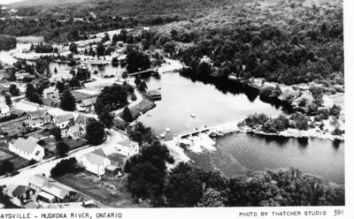
Baysville on Muskoka River
Description
- Media Type
- Image
- Item Type
- Postcards
- Description
- Aerial shot of Baysville, showing the dam on the Muskoka River. The first dam was built of logs and rock in 1873, a second was built in 1918. Finally in 1960 the present dam was opened, replacing the stone masonry dam.
- Date of Publication
- 8 Jun 2016
- Local identifier
- MC # 67
- Geographic Coverage
-
-
Ontario, Canada
Latitude: 45.03341 Longitude: -79.31633
-
- Copyright Statement
- Copyright status unknown. Responsibility for determining the copyright status and any use rests exclusively with the user.
- Contact:
- Bracebridge Public Libraryinfo@bracebridgelibrary.ca
94 Manitoba St.
Bracebridge, ON P1L 2B5
(705) 645-4171


