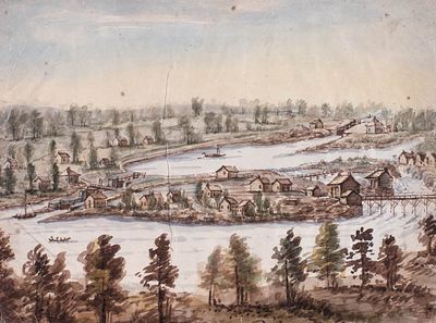
Smiths Falls Lock, Rideau Canada by John Burrows (1789-1848), ca. 1835
Description
- Media Type
- Image
- Item Type
- Watercolors
- Description
- Catalogued by Library and Archives Canada and downloaded from their site - see link at the right of this record.
Hierarchical level: Item
Date: ca. 1835
Reference: Box number: A026-02
Type of material: Art
Found in: Archives / Collections and Fonds
Item ID number: 2833761
Context of this record: John Burrows fonds
Smiths Falls Lock, Rideau Canada, Smiths Falls,
Date(s): ca. 1835
Place of creation: No place, unknown, or undetermined
Extent: 1 watercolour / aquarelle : watercolour over pencil on paper
Inventory no.: 001583
Support: 31.600 X 22.700 cm
Scope and content: The drawing is one of a series (acc. nos. 1979-12-1 to 23)
February 1979 - the drawing is badly creased and is foxed and discoloured. The verso has been reinforced with pieces of paper used to repair the damaged edges of the drawing. There is a tear l.r. and a loss l.l. corner.
Additional name(s): Artist: Burrows, John, 1789-1848
General Note: Set: "Locks Along the Rideau Canal by John Burrows" (Ottawa, ca. 1832), no. 14
Availability of other formats note: Colour transparency available
Signatures and inscriptions note: Inscribed. Signed. Dated.
Inscription: Inscribed verso: in pencil, c. "No. 14. / Smith's Falls Locks".
Container note(s):
C-092886
C-092887
Subject heading:
1. Ontario
2. ONT. : Smiths Falls - ca. 1835
3. SUBJ. - Architecture : View of Smiths Falls Locks on Rideau Canal - ca. 1835
4. Architecture
Source: Private
Other system control no.: ICON1678
Other accession no.: 1979-012 PIC
00005
Ordering and Viewing Options
Conditions of access: Show detail
Terms of use: Credit: Library and Archives Canada, Acc. No. 1979-12-5 Source: Mr. R.W. Henwood, Montréal, Québec.
Copyright: Expired
- Notes
- This watercolour is illustrated in Glenn J. Lockwood's "Smiths Falls: A Social History of the Men and Women in a Rideau Canal Community 1794-1994", p.141 - plate 66, right - the caption reads: "The Smith's Falls lock stations, Ward and Jason islands, as sketched by William Clegg (opposite) and John Burrows respectively, circa 1845. In only a dozen years Smith's Falls ceased to be surrounded by forest (shown in Plate 65) as cleared and fenced fields were laid out. The stone lockmasters' houses were the significant buildings at the combined and detached locks, but already the focus of the village was on the northern shore. This view shows the lengthy bridge from Ward Island in the middle ground to Jason Island behind it, while a tall timber bridge leads from Ward Island to the village proper on the northern mainland. This view was sketched a few years before Frost & Wood moved from Jason Island to the northern riverbank in the foreground of these sketches."
Glenn J. Lockwood. "Smiths Falls: A Social History of the Men and Women in a Rideau Canal Community 1794-1994." Smiths Falls: Corporation of the Town of Smiths Falls, 1994. - Date of Original
- ca. 1835
- Subject(s)
- Geographic Coverage
-
-
Ontario, Canada
Latitude: 44.90011 Longitude: -76.01607
-
- Copyright Statement
- Copyright status unknown. Responsibility for determining the copyright status and any use rests exclusively with the user.
- Contact
- Smiths Falls Public LibraryEmail:info@smithsfallslibrary.ca
Website:
Agency street/mail address:81 Beckwith Street North
Smiths Falls, ON K7A 2B9
Phone number: 613-283-2911


