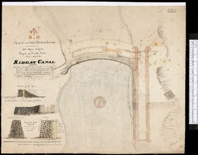
Plan of the Dam & Locks, Old Sly's Rapids, Smiths Falls, 1827
Description
- Media Type
- Image
- Item Type
- Watercolor drawings
- Description
- Catalogued by Library and Archives Canada and downloaded from their site - see link at the right of this record.
Hierarchical level: Item
Date: [1827]
Reference:
Local class no.: H2/410/Rideau Canal/[1827]Box number: 2000216772
Local class no.: H2/410/Rideau Canal/[1827]
Type of material: Maps and cartographic material
Found in: Archives / Collections and Fonds
Item ID number: 4132082
Context of this record: Maps, plans and charts
Ontario - Maps, Charts and Plans
410 - River and lake basins, Province of Ontario
Plan of the Dam & Locks, to be constructed at Old Sly's Rapids; Rapids of Smith Falls; being a part of the Rideau Canal. AA 4.
Date(s): [1827]
Place: S.l.:
Place of creation: Canada
Publisher: s.n.,
Extent: 1 map : Manuscript Original Coloured ; 21 3/4 x 26 1/2.
Additional name(s):
1. Great Britain. Army. Corps of Royal Engineers
2. By, John, 1779?-1836
Additional information:
Source: Private
Other system control no.: CARTO8304
- Notes
- See Glenn J. Lockwood. "Smiths Falls: A Social History of the Men and Women in a Rideau Canal Community 1794-1994." Smiths Falls: Corporation of the Town of Smiths Falls, 1994.
Passfield, Robert W. Building the Rideau Canal: A Pictorial History. Don Mills: Fitzhenry & Whiteside, 1982.
- Date Of Event
- 1827
- Subject(s)
- Geographic Coverage
-
-
Ontario, Canada
Latitude: 44.90011 Longitude: -76.01607
-
- Copyright Statement
- Copyright status unknown. Responsibility for determining the copyright status and any use rests exclusively with the user.
- Contact
- Smiths Falls Public LibraryEmail:info@smithsfallslibrary.ca
Website:
Agency street/mail address:81 Beckwith Street North
Smiths Falls, ON K7A 2B9
Phone number: 613-283-2911


