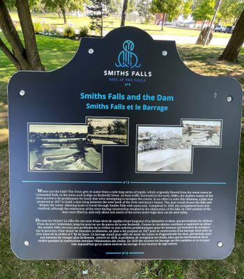
Smiths Falls and the Dam plaque
Description
- Media Type
- Object
- Image
- Item Type
- Photographs
- Description
- Located in Centennial Park at Confederation Drive.
- Notes
- For further information see - Glenn J. Lockwood. "Smiths Falls: A Social History of the Men and Women in a Rideau Canal Community 1794-1994." Smiths Falls: Corporation of the Town of Smiths Falls, 1994.
- Inscriptions
- The text on the plaque reads: "Where are the Falls? The Town got its name from a mile long series of rapids, which originally flowed from the water tower in Centennial Park, to the stone arch bridge on Beckwith Street. As boat travel increased in the early 1800's, the shallow water of the river proved to be problematic for boats that were attempting to navigate its course. In an effort to solve this dilemma, a plan was proposed in 1827 to build a dam lying between the west bank of the river and Jason's Island. This dam would drown the falls and deepen the water, allowing the boats to travel through Smiths Falls with more ease. Completed in 1828, the navigational issue was resolved, although the redirection of the river during construction resulted in the elimination of the falls. In 1959 sections of the dam were filled in, and only about one metre of the seven metre high dam can be seen today."
- Subject(s)
- Geographic Coverage
-
-
Ontario, Canada
Latitude: 44.90011 Longitude: -76.01607
-
- Contact
- Smiths Falls Public LibraryEmail:info@smithsfallslibrary.ca
Website:
Agency street/mail address:81 Beckwith Street North
Smiths Falls, ON K7A 2B9
Phone number: 613-283-2911


