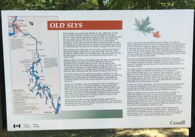
Old Slys' Park Canada plaque, Smiths Falls
Description
- Media Type
- Object
- Image
- Item Type
- Photographs
- Description
- Located near Old Slys Road and Queen Street.
- Notes
- The plaque reads: "This lockstation is named after William Sly who settled here in 1798. A set of rapids fell almost 16 feet (5 m) over a distance of 720 yards (660 m). It was originally proposed to have the lower lock angled back into the river channel built in 1828, at By's urging, the size of the locks were increased from 108 feet (33 m) to 134 feet (41 m) to accommodate steamboats. These larger steamboats would not have been able to make the angled turn, so the locks were set parallel to the shoreline and the canal cut extended below the lower lock to provide a straight entry into the lock. // Many changes have taken place over the years, not the least of which was the almost complete burial of the 21 foot (6.4) high stone dam which blocked the original channel of the Rideau River. The area behind the dam has been filled in over the years and only the top few feet remain visible. // Between 1826 and 1832, an old Indian canoe route along the Rideau and the Cataraqui Rivers were transformed at the command of the British government from the untamed wilderness rivers into the Rideau Canal. The purpose of this remarkable artery was to provide the British army with a safe route for supplying its inland garrisons, avoiding the direct but exposed route along the St. Lawrence which only the disorganization of the American forces had prevented from being cut during the War of 1812. // The 202 km (126 miles) of waterway was made navigable by 47 locks grouped in 24 stations with their associated dams and weirs. The work was designed by the Royal Engineers, commanded by Lieutenant Colonel John By; the actual construction was done by local contractors. // Despite the blockhouses along the waterway, the role of the Rideau has always been peaceful. It was a busy waterway, carrying settlers and supplies into the growing settlement of the interior until the middle of the 19th century, when larger locks were opened on the the St. Lawrence. At the same time, since the possibility of war between Britain and the United States was now unlikely, the British Board of Ordnance signed the system over to the colonial government of Canada in 1856. The period of canal's military administration was over. // Local commercial traffic remained important until the advent of the automobile and better roads around the time of World War I. Since that time recreational boating has grown steadily so that now the system, well into its second century, is busier than ever."
Please see the links at the right of this catalogue record.
For further information see:
Ken W. Watson. A history of the Rideau lockstations. Smith Falls, Ontario: Friends of the Rideau, 2000.
Glenn J. Lockwood. "Smiths Falls: A Social History of the Men and Women in a Rideau Canal Community 1794-1994." Smiths Falls: Corporation of the Town of Smiths Falls, 1994. - Subject(s)
- Geographic Coverage
-
-
Ontario, Canada
Latitude: 44.90011 Longitude: -76.01607
-
- Contact
- Smiths Falls Public LibraryEmail:info@smithsfallslibrary.ca
Website:
Agency street/mail address:81 Beckwith Street North
Smiths Falls, ON K7A 2B9
Phone number: 613-283-2911


