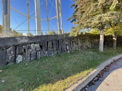
Stone arch dam, Smiths Falls
Description
- Media Type
- Object
- Image
- Item Type
- Photographs
- Description
- The remains of the stone arch dam are located by the Smiths Falls water tower, off Old Mill Road. The top 1.4 m (4 feet) of the original 7 m (23 foot) high are visible. The dam was completed in 1828.
- Notes
- See the Pages box at top of this catalogue record and click the downward pointing select arrow to access additional views of the dam.
For further information see the links to the right of this catalogue record - in particular, Rideau Canal: A History of the Rideau Lockstations, and below:
Ken W. Watson. A history of the Rideau lockstations. Smith Falls, Ont. : Friends of the Rideau, 2000.
Glenn J. Lockwood. "Smiths Falls: A Social History of the Men and Women in a Rideau Canal Community 1794-1994." Smiths Falls: Corporation of the Town of Smiths Falls, 1994. - Date of Original
- 1828
- Subject(s)
- Geographic Coverage
-
-
Ontario, Canada
Latitude: 44.90011 Longitude: -76.01607
-
- Contact
- Smiths Falls Public LibraryEmail:info@smithsfallslibrary.ca
Website:
Agency street/mail address:81 Beckwith Street North
Smiths Falls, ON K7A 2B9
Phone number: 613-283-2911


