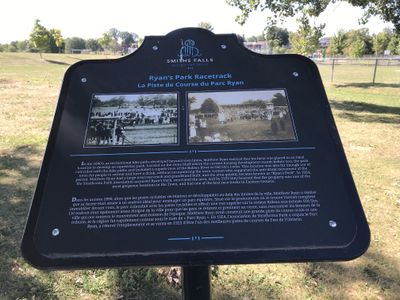
Ryan's Park Racetrack plaque, Lower Reach Park, Smiths Falls
Description
- Media Type
- Object
- Image
- Item Type
- Photographs
- Description
- Lower Reach Park located next to Jasper Avenue and Old Slys Road.
- Notes
- The plaque reads: "In the 1890's, as recreational bike paths developed beyond the town limits, Matthew Ryan realized that his farm was placed in an ideal location to develop an equestrian park. Located on the stone bluff where the current housing development stands before you, the park coincided with the bike paths and included a superb view of the Rideau River at Old Sly's Locks. This location was also far enough out of town for people to retreat and have a drink, without encountering the town women who supported the anti-drink movement of the period. Matthew Ryan had a large oval racetrack and grandstand built, and the area quickly became known as "Ryan's Park". In 1924, the Strathcona Park Association acquired Ryan's Park, renovated the area, and by 1925 they boasted that the property was one of the most gorgeous locations in the town, and had one of the best racetracks in Eastern Ontario."
For further information:
Please see the links at the right of this catalogue record.
Glenn J. Lockwood. "Smiths Falls: A Social History of the Men and Women in a Rideau Canal Community 1794-1994." Smiths Falls: Corporation of the Town of Smiths Falls, 1994. - Subject(s)
- Geographic Coverage
-
-
Ontario, Canada
Latitude: 44.90011 Longitude: -76.01607
-
- Contact
- Smiths Falls Public LibraryEmail:info@smithsfallslibrary.ca
Website:
Agency street/mail address:81 Beckwith Street North
Smiths Falls, ON K7A 2B9
Phone number: 613-283-2911


