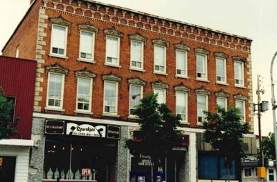
Washburn Block, Smiths Falls, 1989
Description
- Media Type
- Image
- Item Type
- Photographs
- Description
- A 1988 pamphlet located in the Local History collection of the Smiths Falls Public Library was accompanied by a binder containing a photo essay taken on June 15, 1989 by Gary Thubron. (The binder has since been disassembled for preservation purposes). This catalogue record is the digital version of the 1989 photo and corresponding text in the 1988 pamphlet.
Strolling in Smiths Falls: Images of Yesterday, a 1988 walking tour pamphlet, described building 6 as "c.1875. A significant business block in Smiths Falls since its construction; notice the detailed windows and ornamentation in the brickwork below the roof line."
Located at the southwest corner of Beckwith Street and Main Street. (Previously known as Garrett's Block or the Farmer's Exchange).
See the link on the right hand side of this record to view an 1880 image of this building as published in the Illustrated in The Historical Atlas of Lanark & Renfrew Counties, p.31. - Notes
- See the Pages box at top of this page and click the downward pointing select arrow to access a detail sketch and the text in the 1988 pamphlet about this building.
To see the complete pamphlet, please see the link at the right of this catalogue record. - Date Of Event
- 1989
- Subject(s)
- Geographic Coverage
-
-
Ontario, Canada
Latitude: 44.90011 Longitude: -76.01607
-
- Copyright Statement
- Copyright status unknown. Responsibility for determining the copyright status and any use rests exclusively with the user.
- Contact
- Smiths Falls Public LibraryEmail:info@smithsfallslibrary.ca
Website:
Agency street/mail address:81 Beckwith Street North
Smiths Falls, ON K7A 2B9
Phone number: 613-283-2911


