Finding Cramahe's past: Historical directories and gazetteers
Early directories, 1799-1850
Panels
IntroductionEarly directories, 1799-1850Directories, 1851-1899Directories, 1900-1916Cramahe TownshipCastletonColborneDundonaldEdvilleLakeportMorganstonLinks
History of Directory publishing - Library and Archives CanadaChecklist of Canadian directories, 1790-1950 - Internet ArchiveNineteenth Century Directories as Sources in Canadian Social History by Gareth Shaw, ArchivariaAt present two early 19th century directories that document the province of Ontario have been located. "A short topographical description of His Majesty's province of Upper Canada in North America..." which was published in 1799 and "Smith's Canadian gazetteer: comprising statistical and general information respecting all parts of the Upper Province, or Canada West..." which was published in 1846.Both publications contained descriptions of Cramahe Township.As noted in this exhibit's Introduction, directories and gazetteers from this period focussed upon geography and natural resources.

A short topographical description of His Majesty's province of Upper Canada in North America, 1799 Details
"A short topographical description of His Majesty's province of Upper Canada in North America.." was published in 1799 when His Majesty William III reigned as the King of the United Kingdom of Great Britain and Ireland. This directory identified Cramahe township within Northumberland County and provided a minimal geographic description of the township as defined by Murray township's western boundary (present day Quinte West) and Lake Ontario.

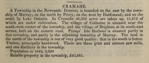
Smith's Canadian gazetteer: comprising statistical and general information respecting all parts of the Upper Province, or Canada West, 1846 Details
In 1846 W.H. Smith published a directory that yielded some tangible information about Cramahe Township. Readers were informed that Cramahe Township was a part of Newcastle district (a district that existed from 1802 to 1849). Cramahe Township’s two sizable villages – Colborne and Brighton – were connected by the 'eastern road.' (This eastern road was the King's Highway 2 (today known as Highway 2 or County Road 2, sections of which were realised from long established Indigenous trails)). Brighton was split between Cramahe Township and Murray Township. The agricultural prospects of Cramahe Township, in particular, soil quality was deemed better in the south than in the north and acreage (overall and cultivated) was noted. Natural resources such as hardwood timber forests received a brief mention. Directories consistently cited the number of grist and saw mills in an area, regarding these entities as an indicator of progress and development - Cramahe Township had 3 grist mills and 16 saw mills. The township also had a distillery. Cramahe statistics included ratable property - 45,681 in pound notes - and a population of 3,200 (in 1842).
(Smith's republished its 1846 publication in 1849, but did not update any information that was relevant to Cramahe).
