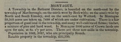
Montague description, Smith's Canadian gazetteer, 1846, exhibit record
Description
- Creator
- Smith, William Henry, Author
- Media Type
- Publication
- Description
- This exhibit record is extracted from the "Smith's Canadian gazetteer: comprising statistical and general information respecting all parts of the Upper Province, or Canada West: distance tables; government and district officers and magistrates in each district; list of post offices, with their distances from some of the principal towns; stage and steamboat fares; principal hotels and taverns; rates of toll on the Welland Canal and some of the principal harbours; lists of exports; quantity of Crown lands for sale in each township; names and addresses of land agents and forwarders; the leading features of each locality as regards soil, climate, &c., with the average value of land. With a mass of other desirable and useful information for the man of business, traveller, or emigrant ... With a map of the Upper Province, compiled expressly for the work, in which are laid down all the towns and principal villages."
See the ‘Other Web sites/External links’ on the right of this record to access - 1) the complete directory/gazetteer in the Internet Archive and 2) selected pages from directory/gazetteer that are relevant to Smiths Falls and Montague Township and catalogued in the Smiths Falls Digital Archive. - Date of Original
- 1846
- Subject(s)
- Geographic Coverage
-
-
Ontario, Canada
Latitude: 44.90011 Longitude: -76.01607
-
- Copyright Statement
- Copyright status unknown. Responsibility for determining the copyright status and any use rests exclusively with the user.
- Contact
- Smiths Falls Public LibraryEmail:info@smithsfallslibrary.ca
Website:
Agency street/mail address:81 Beckwith Street North
Smiths Falls, ON K7A 2B9
Phone number: 613-283-2911


